Tentang Geopark

DEFINITION OF GEOPARK
A single or combined
geographical area that possesses geological heritage sites (geosites) and
valuable landscapes, related to aspects of geological heritage (geoheritage),
geological diversity (geodiversity), biological diversity (biodiversity), and
cultural diversity (cultural diversity). It is managed for the purposes of
conservation, education, and sustainable community economic development with
the active involvement of the public and the local government, so that it can
be used to foster public understanding and care for the earth and the
surrounding environment.
WHAT IS A GEOPARK?
A Geopark is an instrument of
sustainable development for public welfare, which integrates three diversities:
geological, biological, and cultural diversity (UNESCO).
PRESIDENTIAL REGULATION NUMBER 9 OF 2019 CONCERNING EARTH PARKS OR GEOPARKS
An Earth Park (Geopark) is a
single or combined geographical area that possesses geological heritage sites (Geosite)
and valuable landscapes, related to the aspects of Geological Heritage,
Geological Diversity, Biological Diversity, and Cultural Diversity.
BAYAH DOME NATIONAL EARTH PARK (GEOPARK)
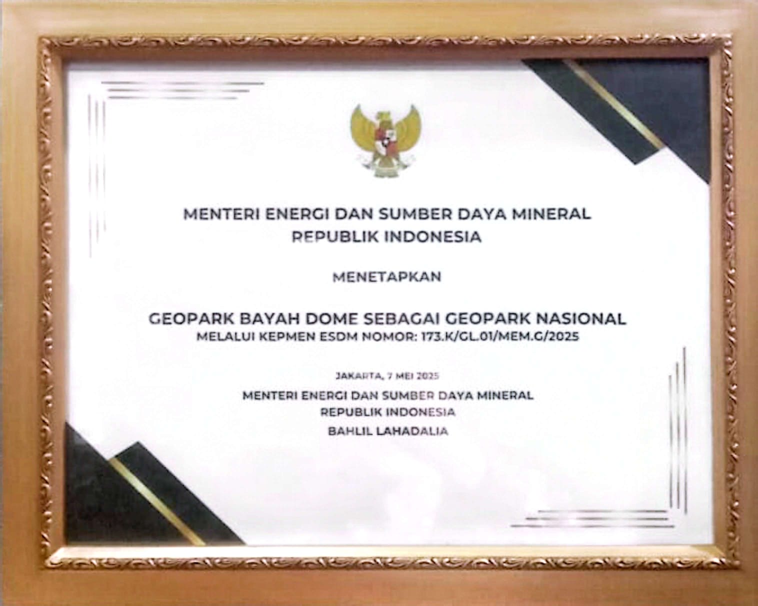
The Bayah Dome National Earth Park (Geopark) was officially designated through the Decree of the Minister of Energy and Mineral Resources of the Republic of Indonesia Number 173.K/GL.01/MEM.G/2025 concerning the Designation of the Bayah Dome National Earth Park (Geopark), which was enacted in Jakarta on May 7, 2025, by the Minister of Energy and Mineral Resources, Mr. Bahlil Lahadalia.
This designation is a national recognition of the rich geological heritage (geoheritage) of the Bayah Dome, which is closely linked to Geological Diversity (Geodiversity), Biological Diversity (Biodiversity), and Cultural Diversity (Cultural Diversity). It simultaneously affirms the Bayah Dome's position as a strategic area for conservation, education, and the development of sustainable geotourism in Lebak Regency, Banten Province.
Based on the assessment results of the National Geopark Verification Team, the Bayah Dome was declared to have met all administrative and technical requirements to be established as a National Geopark. In the decree, the Bayah Dome National Geopark encompasses 32 geological heritage sites (geosites), 6 biological diversity sites (biosites), and 9 tangible cultural sites scattered throughout the Lebak Regency area. This reflects the unique landscape, rich flora and fauna, and distinctive local culture, including the lives of the indigenous Baduy and Kasepuhan communities, all of which form a unified narrative of the geology, nature, and culture of the Bayah Dome.
Furthermore, the ministerial
decree also confirms that the Bayah Dome National Geopark is supported by at
least 5 other important destinations, such as the Multatuli Museum, Bagedur
Beach, Pulomanuk Beach, Cibolang Slope, and Tirta Lebak Buana. This designation
serves as a reference for spatial planning at the national, provincial, and
regency/city levels, and as a guideline in the preparation of Regional
Development Plans. The management of the Bayah Dome National Geopark is carried
out in accordance with prevailing laws and regulations and technical guidelines
for geopark management, with the obligation to submit periodic reports to the
Minister of Energy and Mineral Resources through the Head of the Geological
Agency every two years. With this strong legal basis, the Bayah Dome National
Geopark is expected to be a driving force for sustainable development,
improving community welfare, and strengthening the image of Lebak Regency and
Banten Province at both national and international levels.
National Geopark Decree for Bayah Dome Geopark